Publish Date: September 11, 2023
Researchers at IIT Delhi Develop First National-Scale Mapping of Soil Erodibility
Share this on
New Delhi: The process of soil erosion starts when rainfall occurs on the soil or when water flow (runoff) displaces the soil particles.
Soil erodibility is the susceptibility of soil particles from becoming detached and reflects the combined effect of rainfall, infiltration, and runoff. It is one of the major factors used to estimate soil loss and reflects the effect of soil structure, texture, permeability, and organic matter content in countering soil erosion.
Till now, soil erodibility assessments have been conducted in specific regions or catchments, but a national-scale assessment of soil erodibility was required. Now, researchers at IIT Delhi have developed a national-scale mapping of soil erodibility, a first of its kind in the country.
This national-scale mapping of soil erodibility highlights specific areas where the soil is most prone towards erosion.
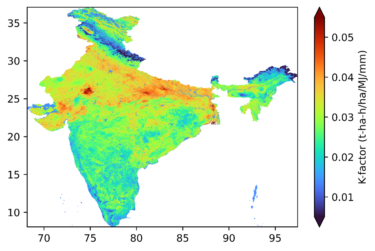
(Photo: National Soil Erodibility Map for India)
The researchers in their study have found that out of the 50 districts with the most erodible soil, 29 are in Uttar Pradesh, 13 are in Bihar, 3 in Gujarat, 2 each in Haryana and Rajasthan, and 1 in Punjab.
“This reflects the combine contribution to erosion due to rainfall, runoff, land use, land cover, deforestation, and agricultural practices. This study fills a critical gap and brings us one step closer to estimating soil loss at a national level and developing a soil erosion model”, said Prof. Manabendra Saharia, Department of Civil Engineering, IIT Delhi.
Prof. Saharia added, “Soil erosion is a significant trigger for land degradation and a major global geo-environmental issue. Being able to assess its causes and impacts at a high-resolution will help us develop a national soil conservation plan that can help our vital agricultural sector”.
The study by Mr. Ravi Raj (PhD Scholar), Prof. Manabendra Saharia and Prof. Sumedha Chakma from the Hydrosense Lab (https://hydrosense.iitd.ac.in/), Department of Civil Engineering at IIT Delhi, exploring the spatial variation of soil erodibility and its relationships with soil properties in India was published in CATENA (https://doi.org/10.1016/j.catena.2023.107271).
The dataset has been freely released as the Indian Soil Erodibility Dataset (ISED, https://zenodo.org/record/8011445) at a spatial resolution of 250 m.
The study estimated the national average soil erodibility factors for India as 0.028 and 0.034 t-ha-h/ha/MJ/mm using Nomograph and EPIC models, respectively.
The researchers found histosols soil type as least susceptible to soil erosion, having the lowest average K-factor (0.011 t-ha-h/ha/MJ/mm), while the Xerosols soil type was observed as most susceptible to soil erosion, having the highest average K-factor (0.034 t-ha-h/ha/MJ/mm) corresponding to the soil classes in Indian conditions.
In addition to this, the researchers conducted a comprehensive statistical analysis of the soil erodibility map to visualize its distribution over the national territory in terms of the different soil types, textures, and percentage ranges of erodibility values. The results indicated that the K-factor, estimated using the Nomograph approach, exhibited a stronger correlation with the observed K-factors retrieved from the literature.
They further suggested that the CLOM factor, which indicates the availability of soil organic carbon content, showed a high correlation with the K-factor, specifically in the Indian region, among the erodibility indices. This study develops a comprehensive understanding of soil erodibility and its indices over India and will be an important dataset to perform soil loss estimations at a national scale.
******
Other News
IIT Delhi Researchers Develop High-Efficiency Silicon Heterojunction (SHJ) Solar Cells with Power Conversion Efficiency of >23%
Read More
IIT Delhi Researchers Develop High-Speed, Self-Powered Photodetector for Next-Gen Optical Communication
Read More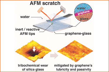
Atomically thin graphene coating effectively protects glasses from simultaneous mechanical and chemical damage under water: Study
Read More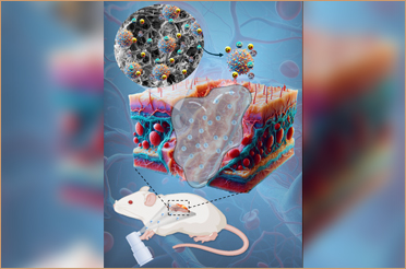
Sprayable Hydrogel by IIT Delhi Researchers for Improving Wound Healing Exhibits Promising Results in Pre-Clinical Trial
Read More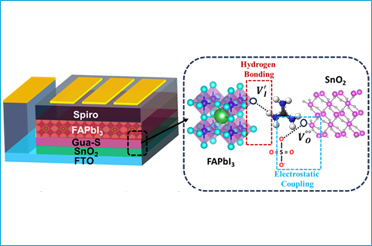
IIT Delhi Researchers Find a Potential Solution to Develop Perovskite Solar Cells Under Air Ambient Conditions Without Using Anti-Solvents
Read More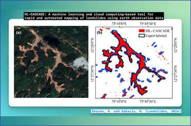
IIT Delhi Researchers Develop and Release a Machine Learning and Cloud Computing Based Tool for Rapid and Automated Mapping of Landslide Extent
Read More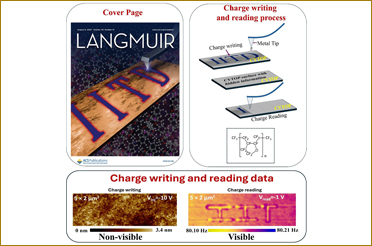
IIT Delhi Researchers Demonstrate a New Polymeric Material Having Potential to Develop Advanced Electronic Devices for Data Storage and Encryption
Read More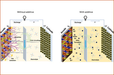
IIT Delhi Researchers Find a Potential Solution to Regulate Dendrite Growth in Room-Temperature Sodium-Sulfur Batteries
Read More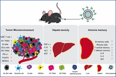
IIT Delhi Scientists Working on Cure for Brain Cancer Gets Promising Results in Pre-Clinical Trials
Read More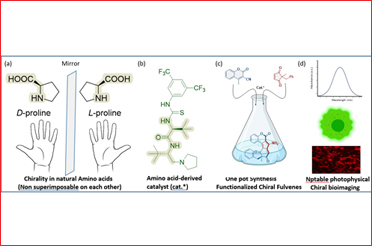
National Centre for Assistive Health Technologies (NCAHT) at IIT Delhi Launches Assistive Technology Products for Visually Challenged
Read More
First-Ever Brain Imaging Study on Yoga Nidra Finds Significant Changes in the Brain’s Functional Connectivity during the Practice
Read More
Hinglish Helps Users Engage More Effectively with a Broader Audience On Social Media: Study
Read More
IIT Delhi Researchers Develop Highly Efficient Terahertz Radiation Source for Beyond 6G Technology
Read More

A Study by IIT Delhi Researchers Proposes Solutions for Fair Compensation to Food Delivery Agents in India
Read More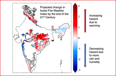
Rural Technology Action Group at IIT Delhi Transfers “AC Motor-Powered Wooden Bead Making Device” Fabrication Technology to Industry
Read More
Researchers Develop Real-Time Bioelectrochemical Sensor for Rapid Water Quality Monitoring
Read More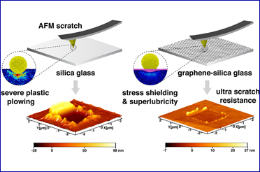
IIT Delhi Researchers Find Ultrathin Graphene Coating Can Make Glasses Extremely Scratch-Resistant
Read More
Researchers and Practitioners Propose Creation of a New Mission Energy Access Programme to Support Global Goal of Ending Energy Poverty by 2030
Read More
Researchers to Global South: Use Emerging Technologies and Strengthen International Collaboration to Overcome Challenges in Adapting to Climate Change
Read More
IIT Delhi Researchers Develop Scalable Wearable Pressure Sensor That Can Help Doctors and Specialists Analyze Gait Patterns and Postural Deformities
Read More
Researchers at IIT Delhi Achieve Trusted-node-free Secure Quantum Communication for 380 km in Standard Telecom Fiber
Read More
IIT Delhi's Exoskeleton Device Heads for International Footprint to Australia for Clinical Trials in Collaboration with Proxmed
Read More
Researchers Develop a Simulation Tool for Planning Operational Response During a Health Crisis
Read More
AI/ML Model Developed by IIT Delhi-led Researcher Predicts 2023 to be a Normal Monsoon Year
Read More
Researchers at IIT Delhi Develop Mobile Robot “Robomuse 5.0” Capable of Carrying Payloads Up to 100 kg
Read More
Evidence of Structural Brain Plasticity Observed Following Treatment to Congenital Blind Humans
Read More
Researchers at IIT Delhi and IIT Bombay Develop Highly Efficient Spintronics-Based Neuromorphic Hardware
Read More
Researchers' Efforts to Develop a Next-Generation Vaccine Against COVID-19 Give Promising Results in Animal Trial Phase
Read More
Researchers Led by IIT Delhi Scientist Develop a VLP-based Vaccine Candidate Against COVID-19
Read More
IIT Delhi Showcases Technologies with Societal Impact, Innovations in Clean Energy, Healthcare, Manufactuting at All IITs R&D Fair IInvenTiv
Read More
IIT Delhi Launches Mobile Application ‘IITD Aab Prahari (आब प्रहरी)’ to Address Waterlogging Issues in Urban Areas During Monsoon
Read More
IIT Delhi Researchers Propose Non-invasive, Time Efficient and Patient Friendly Diagnostic Tool for Epileptogenic Zone Detection
Read More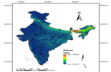
Researchers at IIT Delhi Develop Map to Highlight Areas Prone to Rainfall-induced Erosion in India
Read More
Researchers at IIT Delhi Demonstrate How Polyarylquinone Molecule Can be Synthesized Easily
Read More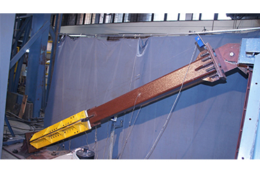
IIT Delhi Researchers Develop Low-Cost Buckling Restrained Braces That Can Improve Earthquake Resistance of Structures
Read More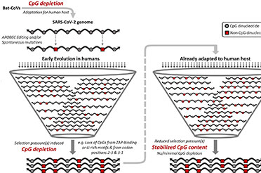
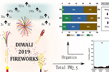
Biomass Burning Drives Poor Air Quality in Delhi Post Diwali, Not Fireworks: IIT Delhi Study
Read More
Researchers Led by IIT Delhi Develop Technology to Enable Use of Environment-Friendly Dimethyl Ether as Fuel in Automotive Vehicles
Read More
IIT Delhi Researchers Design and Demonstrate a New Strategy for Development of Drug Molecules
Read More
IIT Delhi Researchers Develop High Efficiency, Shadow-less, Portable Solar PV Towers for Power Generation
Read More

RT-PCR-based Assay for Identification of Omicron Variant of SARS-CoV-2 Developed at IIT Delhi
Read More
IIT Delhi Researchers Develop Catalytic Technology for Sustainable Production of Chiral Active Pharmaceutical Ingredients
Read More

IIT Delhi, RDSO Researchers Develop Easy to Use Train Simulation Software ‘Runtrain#’ to Help in Train Timetabling Methods
Read More
IIT Delhi Researchers Develop Modified Cotton Fabric Capable of Adsorbing Harmful Air Pollutants from Air
Read More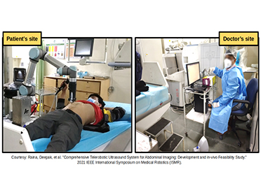
IIT Delhi, AIIMS New Delhi and Addverb Co-develop Telerobotic Ultrasound System During COVID Times
Read More
IIT Delhi Researcher in Collaboration with NUS Designs Device for High Density Magnetic Memory
Read More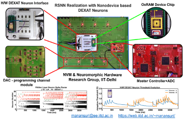
IIT Delhi Researchers Demonstrate a New Brain-inspired Artificial Neuron for Building Accurate and Efficient Neuromorphic AI Systems
Read More
IIT Delhi Scientist led Research Team Develops Novel Antifungal Strategy for Fungal Eye Infection
Read More
Minister of State for Education Shri Sanjay Dhotre launches the Rapid Antigen Test Kit for COVID-19 developed by IIT Delhi
Read More
Technology for Hydrogen Utilization in Spark-Ignition Engine Generator for Electricity Generation with Zero-Emission Developed by IIT Delhi Researchers
Read More